Fires - Wildfire Info & Atlas 4.1.1
Free Version
Publisher Description
Fires is a comprehensive wildfire information resource and atlas.
▶▶ WILDFIRE INFORMATION RESOURCE
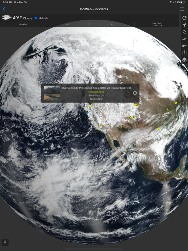
▶ Incident Details
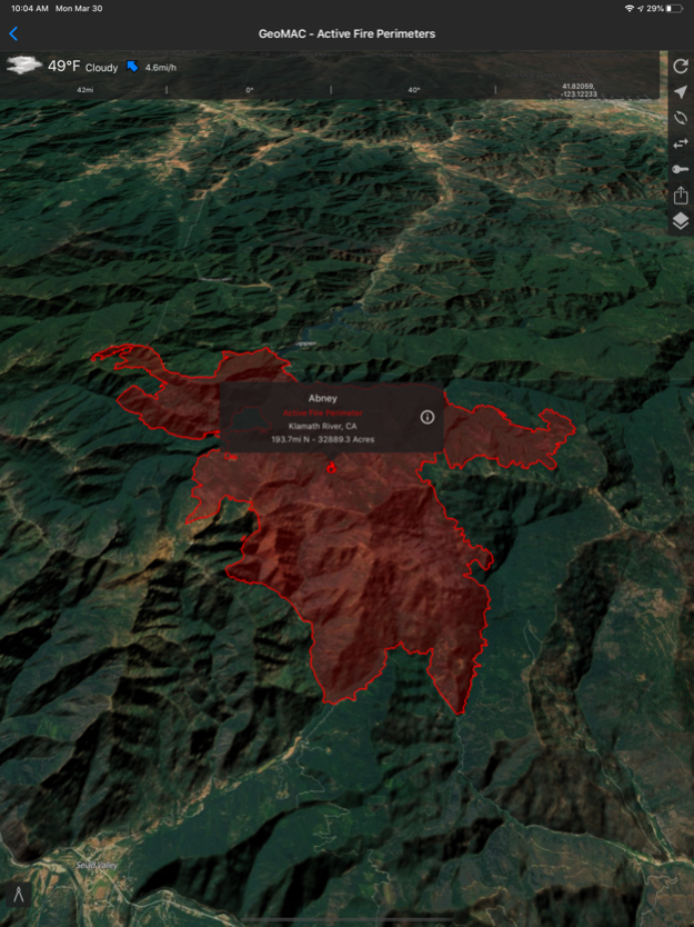
Fires provides maps, photos, and information about wildfires from several sources for the United States. View active wildfire perimeters or share wildfire information and high resolution photos.
• InciWeb
• CAL FIRE
• NIFC
• US Forest Service
▶ Incident Notifications with Containment Updates
Fires will notify you when new incidents are downloaded within the maximum distance that you set from the source that you select.
• InciWeb
• CAL FIRE
• US Forest Service
▶ Offline Incident Mapping
Fires can automatically download incidents when the app is in the background from the source that you select.
• InciWeb
• CAL FIRE
• US Forest Service
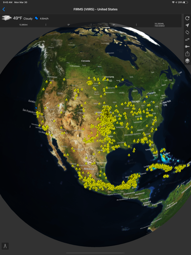
▶ Thermal Hotspots and Fire Activity
Fires allows you to interactively browse the full set of global active fire detections from MODIS and VIIRS.
• Collection-6 MODIS Active Fire Data
• VIIRS I-Band 375m Active Fire Data
• Active Fire Details
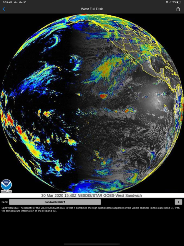
▶ GOES and Himawari Satellite Images and Animations
Fires provides extensive near real-time GOES (Geostationary Operational Environmental Satellite) imagery from NOAA.
• United States
• Pacific
• Atlantic
• Central America
• South America
• East Full Disk
• West Full Disk
▶ Local Weather Conditions
Fires gives you a summary of your current local weather conditions from AccuWeather for free without a subscription.
▶▶ ATLAS
▶ Offline 3D Maps and GPS
Fires will give you offline GPS functionality and 3D maps when there is no network coverage.
• Several Basemaps
• 20 Bureau of Land Management (BLM) Reference Maps for California, and we are currently adding many more to this collection.
• 21 United States Forest Service (USFS) National Forest Maps for California, and we are currently adding many more to this collection.
• Create Lines, Shapes, and Waypoints
• Navigate and trace your locations
▶▶ SUBSCRIPTIONS
Subscriptions automatically renew unless auto-renew is turned off at least 24 hours before the end of the current period. Your iTunes account will be charged for renewal within 24 hours of the end of the current period, and identify the cost of the renewal.
▶ FIRES PRO ELITE ($19.99/year)
Yearly access to the entire Fires Atlas, this includes unlimited access to all the Basemaps, BLM reference maps, and USFS reference maps.
• Access Incident Weather Conditions.
• Remove Ads.
• 7 day free trial.
▶ FIRES PRO ($14.99/year)
Yearly access to all the Basemaps along with yearly access to 4 BLM and USFS reference maps. Each reference map selection will last for 3 months at a time. After 3 months each reference map selection expires, then you can change that selection to any other reference map in the Fires Atlas.
• Access Incident Weather Conditions.
• Remove Ads.
• 7 day free trial.
▶ INCIDENT WEATHER CONDITIONS ($5.99/year)
• Access Incident Weather Conditions
▶ REMOVE ADS ($2.99/year)
• Use the app without ads
▶ TO MANAGE YOUR SUBSCRIPTION:
• TURN OFF auto-renewal via the main Settings app: http://support.apple.com/kb/ht4098
• Subscriptions automatically renew unless auto-renew is turned off at least 24 hours before the end of the current period. Your iTunes account will be charged for renewal within 24 hours of the end of the current period, and identify the cost of the renewal.
• Your iTunes Account will be charged at confirmation of purchase.
• Visit the following URL to view our Privacy Policy: http://www.livewaremedia.com/p/privacy-policy.html
• Visit the following URL for full terms of use: http://www.livewaremedia.com/p/terms-and-conditions.html
Apr 11, 2024
Version 4.1.1
Map updates.
About Fires - Wildfire Info & Atlas
Fires - Wildfire Info & Atlas is a free app for iOS published in the Recreation list of apps, part of Home & Hobby.
The company that develops Fires - Wildfire Info & Atlas is Ryan Strouse. The latest version released by its developer is 4.1.1.
To install Fires - Wildfire Info & Atlas on your iOS device, just click the green Continue To App button above to start the installation process. The app is listed on our website since 2024-04-11 and was downloaded 7 times. We have already checked if the download link is safe, however for your own protection we recommend that you scan the downloaded app with your antivirus. Your antivirus may detect the Fires - Wildfire Info & Atlas as malware if the download link is broken.
How to install Fires - Wildfire Info & Atlas on your iOS device:
- Click on the Continue To App button on our website. This will redirect you to the App Store.
- Once the Fires - Wildfire Info & Atlas is shown in the iTunes listing of your iOS device, you can start its download and installation. Tap on the GET button to the right of the app to start downloading it.
- If you are not logged-in the iOS appstore app, you'll be prompted for your your Apple ID and/or password.
- After Fires - Wildfire Info & Atlas is downloaded, you'll see an INSTALL button to the right. Tap on it to start the actual installation of the iOS app.
- Once installation is finished you can tap on the OPEN button to start it. Its icon will also be added to your device home screen.
